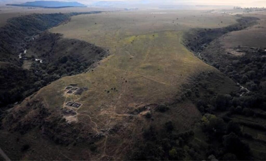
On a promontory in southern Georgia, between two deep gorges carved by ancient rivers, stone walls have stood for more than three millennia. The site, known as Dmanisis Gora, first drew the attention of archaeologists in 2018 when test excavations began on a fortified inner core. From the ground, the fortress appeared impressive but unremarkable by regional standards, a defensible position with a double wall, perhaps the seat of a local Bronze Age chieftain.
When the knee-high summer vegetation died back, researchers from Cranfield University and the Georgian National Museum noticed something unexpected. Beyond the known fortress walls, scattered across a vast plateau, lay the remains of additional fortifications and stone structures. The site was far larger than anyone had realized. From ground level, the full extent remained impossible to grasp. That limitation led to an unusual solution: a drone carrying a positioning system accurate to less than two centimeters.
A Fortress Hidden in Plain Sight
The unmanned aerial vehicle flew systematic passes over 115 hectares of rugged terrain, capturing nearly 11,000 high-resolution photographs. Back in the lab, researchers stitched those images together into orthophotos—composite pictures where every point appears as if viewed straight down—and digital elevation models that revealed subtle topographic features invisible to the naked eye.
The results, published in the journal Antiquity, upended decades of assumptions about the site. Dmanisis Gora was not a 1.5-hectare fortress with a small outer enclosure. It was a mega fortress covering approximately 80 hectares, with an outer settlement defended by a 1-kilometer-long fortification wall running from gorge edge to gorge edge.

Dr. Nathaniel Erb-Satullo, senior lecturer in architectural science at Cranfield Forensic Institute and the study’s lead author, said the drone survey showed the site was more than 40 times larger than originally thought. “The use of drones has allowed us to understand the significance of the site and document it in a way that simply wouldn’t be possible on the ground.”
What the Stones Reveal
To confirm that the features spotted from the air were truly ancient, the team compared their drone images with 50-year-old photographs taken by a Cold War-era spy satellite declassified in 2013. That comparison helped distinguish recent agricultural features from Bronze Age structures and showed which parts of the settlement had been damaged by modern farming.
What emerged was a complex landscape. The inner fortress, roughly 1.5 hectares, featured two substantial defensive walls with a third wall running between them, an unusual configuration suggesting layered defenses. Excavations there have yielded more than 30,000 pottery sherds from the Late Bronze and Early Iron Age, along with animal bones and evidence of metalworking.

But the outer settlement proved the greater surprise. Within the 1-kilometer wall, researchers mapped hundreds of rectilinear and curvilinear stone structures, many of them compounds 15 to 40 meters across. Some may have served as animal pens or unroofed courtyards. Others appear to be dwellings. Stone cromlechs, burial structures typical of the second and first millennia BC, were scattered throughout the settlement rather than confined to a separate cemetery.
The settlement’s total defended area, about 56 hectares, approaches or exceeds the walled areas of major medieval cities in the region, including the nearby medieval town of Dmanisi itself.
A Seasonally Expanding City?
Yet for all the stone construction, something about the outer settlement puzzles archaeologists. Sediment layers there are thin. Surface ceramics are almost entirely absent. The combination suggests low-intensity or intermittent occupation, people who built substantial walls and structures but did not leave behind the deep deposits of debris typical of year-round settlements.
Erb-Satullo and his colleagues propose a hypothesis. Dmanisis Gora sits in a transitional zone between lowland agricultural areas and highland pastures, on routes still used today by seasonal herders. The mega fortress may have served as a staging ground for mobile pastoral groups who gathered at the site during spring and autumn migrations.

“We hypothesize that Dmanisis Gora expanded because of its interactions with mobile pastoral groups, and its large outer settlement may have expanded and contracted seasonally,” Erb-Satullo said.
If correct, the pattern would align with archaeological theories suggesting that mobile pastoralism remained central to Late Bronze and Early Iron Age societies in the Caucasus, even as fortified settlements appeared across the landscape. The inner fortress, with its year-round occupation evidenced by deep stratification and pig remains, may have housed a permanent population while the outer settlement swelled and shrank with the seasons.
A New Kind of Ancient Urbanism
The South Caucasus saw the emergence of fortress settlements between roughly 1500 and 500 BC, a period when societies across the Near East and Eastern Mediterranean experienced collapse and reorganization. Unlike many of those regions, the Caucasus showed remarkable continuity across the Bronze Age–Iron Age transition.
Dmanisis Gora now offers one of the clearest examples of how those societies organized themselves on a large scale. The site’s structure, a small, heavily fortified core surrounded by a vast, lower-density outer settlement, has few documented parallels in the region. The mismatch between the scale of stone construction and the apparent thinness of occupation suggests a form of settlement where population density remained low even as the built environment grew.

That pattern adds a new dimension to global debates about ancient urbanism. Large settlements do not always fit traditional models of cities with dense populations and hierarchical organization. Some, like Dmanisis Gora, may have functioned as communal gathering places where permanent residents and mobile groups intersected, their populations fluctuating with the seasons and the movement of livestock.
With the site now extensively mapped, the research team is conducting further excavations. Tens of thousands of pottery sherds, animal bones, and other artifacts recovered since the aerial survey will help clarify questions of population density, livestock movements, and agricultural practices.