It was a bright, clear April morning when Russell and Gail Lee visited Null Island for the first time.
The couple was aboard a 2023-2024 Viking World Cruise, about 380 miles off the coast of West Africa, approaching the coordinates at 0 degrees latitude and 0 degrees longitude, where the equator and prime meridian intersect.
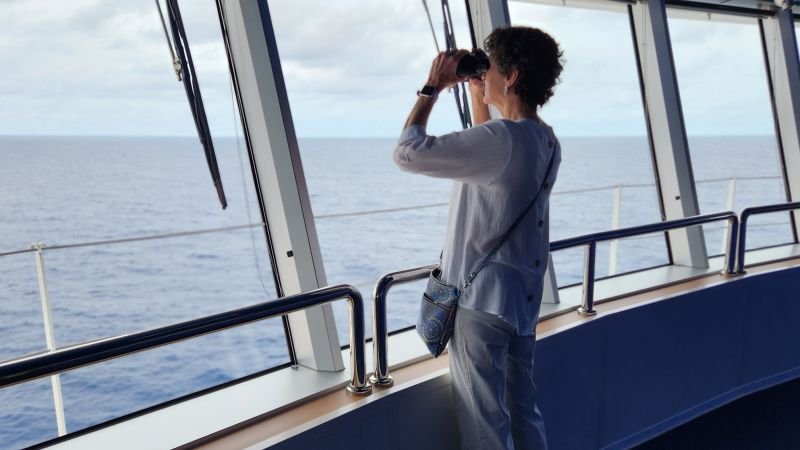
Russell stood on the bridge with the captain, while Gail and a shipload of fellow cruisers gathered on the bow.
“Everyone had their geolocators out, counting down … 0.01… 0.005 … 0.0001,” Gail Lee tells CNN Travel. “We were all comparing phones. Whoever took a selfie closest to 0, 0 got bragging rights.”
When they learned the ship would make a “stop” at Null Island, the Lees, who work as enrichment lecturers on cruises, even offered to deliver scenic commentary.
The only problem? There was nothing to see but open ocean in every direction.
That’s because Null Island isn’t actually a place at all.

It’s a long-running inside joke born from mapping errors and embraced over the years by geospatial professionals — people who work with mapping software and location data.
Everything from Strava runs and Airbnb listings to hotels and crime reports tied to missing or miscoded location data has accumulated at these coordinates, giving rise to a phantom destination with a surprisingly devoted following.
And while still rare, a small number of cruise itineraries have begun passing through, adding to the fanfare.
Just a few weeks ago, Holland America announced plans to include Null Island as a stop on its 129-day round-the-world voyage in 2028, following an earlier stop on its 2024 trip. While Viking does not list any stops on upcoming itineraries, its ships in 2024 and 2025 visited the coordinates.
“There is no ‘there’ there,” says Russell Lee, who visited Null Island with Viking in both 2024 and 2025.
“There’s really nothing. Just open sea. But you’re some of the only people on Earth ever to visit, and that is really special.”
An island that doesn’t exist

Humans have long been drawn to invisible geographic markers — the equator, the Arctic Circle, the continental divide — and Null Island may be the internet age’s strangest version of that phenomenon.
But what is it, exactly?
It started popping up in the Geographic Information Systems community around 2008.
As geospatial data became more widely used — fueled by early platforms like Twitter (Now X) and Flickr — the placeholder point at 0, started as a technical issue.
“One common screw-up with location data is that you accidentally leave it off,” Mike Migurski, a geospatial data specialist, tells CNN Travel.
At the time, Migurski was working at data visualization and cartography studio Stamen Design, where he began noticing a lot of data “floating around the Bight of Benin, where there shouldn’t be any.”
Incomplete or missing location data, he explains, defaults to “null” or 0. And those zeros — 0 degrees latitude, 0 degrees longitude — point to a remote spot in the Gulf of Guinea.
As a result, that’s where everyone’s unassigned data would wind up, he adds. And that’s how Null Island was born.

What began as something of a collection point for mapping errors soon evolved into a quirky fictional world built by those in the know.
In 2010, while working on a new set of map designs for GeoIQ, a location intelligence platform, Migurski helped give the island a visual identity.
Inspired by the popular video game “Myst,” he added a small island shape at 0, 0 as an Easter egg for others to find.
“It helped crystallize for people that it was something you could picture,” Migurski says. “We didn’t do any kind of explicit reference,” he continues. “It was just an ‘If you know, you know,’ thing.”
The visual quickly spread through the mapping world, appearing on company T-shirts and conference swag before eventually making its way into Natural Earth, one of the most widely used open-source mapping datasets, in 2011.
Around that same time, a developer named Steve Pellegrin leaned fully into the joke, creating a tongue-in-cheek website imagining Null Island as a real destination, complete with its own flag, history and economy.
The island, according to the site, had a population of 4,000, “the highest per-capita Segway ownership in the world,” and a local language known as “Nullish.”
Curious travelers were encouraged to call their agents and book a getaway to a destination described as “like no place on Earth.”

Null Island’s popularity continued to grow online, primarily on early social media platforms like Twitter and in GIS forums.
Those in on the joke would quip about “checking in” for a stay on the island or share screenshots of apps that erroneously placed them at those coordinates.
From there, Null Island steadily found its way into a much broader conversation.
Blogs, YouTube videos and forums embraced the concept, followed later by outlets including the Library of Congress, Atlas Obscura, VICE and The Wall Street Journal.
What made it resonate, Migurski offers, may be something surprisingly universal: people tend to be fascinated by the arbitrary markers and systems we use to organize the world, especially when those systems take on lives of their own.
For years, that mythology was strengthened by the presence of a NOAA weather observation buoy nicknamed “Soul,” anchored near 0,0. Over time, the buoy became closely associated with Null Island before it was later decommissioned in 2021.
The internet’s ‘lost and found’

Beneath the humor and internet folklore lies a very real issue.
Around the time Null Island was becoming an online curiosity, Levente Juhász, an assistant professor of Geospatial Analytics at the University of Florida, began looking at it more closely.
“Seeing these discussions and debates, I realized it was not just purely funny … because it is a fundamental issue in data quality,” Juhász, who co-authored an academic paper on Null Island in 2022, tells CNN Travel.
Diving into the research, he and co-author Peter Mooney found everything from misplaced photos to phantom businesses mapped to the same coordinates — a kind of digital “lost and found.”
And while many of the errors were harmless, the implications weren’t always trivial, especially in a world that depends so heavily on digital mapping tools.
“Think about emergency services,” he says. “What would happen if a dispatcher tried to route a fire truck to the middle of the ocean? We would lose precious time.”
Null Island also serves as a reminder that maps are not infallible.
“People like maps and tend to trust them,” he says. “Once you put a place on a map, it becomes real. A map carries a sense of authority — and these days, travelers really rely on them because they don’t have that local knowledge.”

For cruisers Russell and Gail Lee, the appeal of Null Island was less about the technical backstory and more about the lore and rarity surrounding it.
“Visiting 0, 0 and Null Island is a major thing,” says Gail Lee. “Like crossing the Arctic Circle, the equator or the International Date Line — it’s another imaginary place you’ve been.”
In that sense, it belongs to a loose but enduring category of destinations defined by geographic boundaries, landmarks and superlatives.
The northernmost point. The southernmost tip. The four corners. The prime meridian. The equator. The continental divide.
Russell Lee, who has spent years delivering historic, cultural and scenic commentary on cruise ships, sees these places as part of a continuum that merges geography, mythology and storytelling.
When faced with a stretch of ocean where there was nothing to see but slow-rolling swells, he filled the void with stories of other invented places.
He told the cruisers all about Atlantis, the lost city said to have slipped beneath the sea, and Antillia, a “phantom island” that haunted medieval and early modern maps of the Atlantic.
Then there was Agloe, a fictitious town planted in upstate New York as a cartographic trap to catch plagiarism, which, improbably, became real enough to appear on road signs.
They’re locations, he says, that continue to capture the imagination.
And that’s exactly why he thinks Null Island has had such broad appeal beyond the world of digital mapping and data analysts.
For the Lees — seasoned travelers who spend most of their time at sea — that mix of mystery and geographical curiosity was all part of the appeal.
“We were absolutely thrilled to sail past 0, 0 and ‘visit’ Null Island,” says Russell Lee.
“We never thought we’d get to do that. For many of us, it turned out to be one of the highlights of the trip.”